Sunday, November 29, 2015

November 23, 2015 - Back to DuPont State Forest

There's still lots more to see in DuPont (and it's fairly close by), so Cindy and I headed back there again today.  The first trail on the list was the 3 Lakes Trail, so we parked at the High Falls access area and headed towards Conservation Rd.  As soon as we crossed the covered bridge, we noticed the boggy area on the right had a thin coat of ice on it with some unusual patterns in it.  Time for some pictures.


We began the 3 Lake Trail at the end off of Conservation Rd which is about 1.25 miles from the parking area.  The trail is listed at 0.8 miles in length and is an easy stroll through a mostly white pine section of the forest.  The largest of the lakes, Lake Julia, is the first of the 3 lakes that the trail passes, but the view of the lake is through the trees, so I didn't take any shots.  Better views of the lake can be had from other trails.  The next lake is the smallest of the 3 and is Lake Alford.  This one is a very scenic little lake (more pond size) with a small pier and covered sitting area.  There's also a picnic table.  We were both saying how nice this would look covered in snow and plan to come back if it ever does snow.


Lake Alford

The last lake is Lake Dense and I'm guessing it gets a lot of visitors in the summer months.  It's quite a bit bigger than Lake Alford and there are 2 piers where you can fish from or I'm assuming dive from.  There's aren't any 'no swimming' signs. 


Lake Dense with Joanna Mountain in the background

Soon after Lake Dense, the 3 Lakes Trail ends on Joanna Rd.  We headed right on Joanna Rd and on to a trail that is no longer maintained and isn't on the new maps, the Joanna Mountain Trail.  The road began to climb and maybe gained 200' in elevation in about 1/2 mile.  At this point, Chestnut Oak Rd turns to the left.  We stayed on Joanna Rd, but would take this road on the way back.  In just under a mile up Joanna Rd, the road splits.  There were no signs, but we knew the right fork would take us towards Joanna Mountain.  The left fork stays on Joanna Rd.  We passed a pretty big clear cut area on the left, then the road ended and the 'trail' continued up the mountain.  After a short distance, it just ended.  We were hoping there would be a view of the lakes, but getting to the top and over to the view side was going to require a slippery scramble up a rock face with delicate vegetation, so we passed on that and just headed back.

We had another destination marked in the GPS for investigation on down Joanna Rd, but decided that would be best saved for another day.  Instead of going back the exact same way, we opted to take Chestnut Oak Rd to Buck Forest Rd near Grassy Creek Falls, then take Buck Forest Rd pack to the parking area which gave us a hike of about 5.5 miles.  

Sunday, November 22, 2015

November 20, 2015 - Exploring Trails in DuPont State Forest

DuPont State Recreational Forest has a lot of trails that Cindy and I haven't been on yet, so a couple or 3 of those were on today's agenda.  Cindy picked out the Plantation Trail as out first stop.  The trail head is 3.3 miles down Sky Valley Rd on the right side.

The trail is relatively flat and is very easy if you are looking for a nice hike in the woods where you probably won't see very many - if any - other people. The hike is an out and back and is about 1.75 miles total.  The first section of the hike is through a section of forest that is mostly white pine.  I noticed the foliage of Trailing Arbutus (Epigaea repens) in several spots.  This low growing wildflower is one of the first to bloom and can be seen blooming in late March to early April.  There was also quite a bit of Galax (Galax urceolata) foliage which usually blooms in May. 

Just over 1/2 mile into the hike, the trail splits.  This is actually the beginning of a loop, so you can go either way. We followed the loop clockwise.  The trail got a little more interesting along the loop.  We came upon a big boulder that was probably mostly buried.  The part that was showing was home to a variety of mosses, ferns, and lichens, but the interesting thing was the holes in the rock that looked like they were caused by erosion.  There's no water source nearby, so maybe from rainfall over thousands of years??


A short time later on the loop we came across this tree.  There's a similar one I call the antelope tree near Skinny Dip Falls, but it has 2 'horns' and this one only has one.  We thought it was interesting.


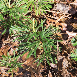
The trail then passed through a section of Rosebay Rhododendron, Mountain Laurel, and what looked like Carolina Rhododendron before completing the loop.  I also spotted a couple of different types of Lycopodium along the trail.  These are fairly common in some mountain areas and are also knows as ground pines and creeping or running cedar.

 
Lycopodium obscurum
Lycopodium digitatum


Next on the list was the Flat Rock Trail which we had passed on Sky Valley Rd on the way to the Plantation Trail.  This trail is also an out and back trail for a total of 1 mile.  It ends at Grassy Creek at a point where another unnamed creek joins Grassy Creek. 


the end of Flat Rock Trail

There's really nothing exciting about this trail, but it would be interesting to go back in the Spring to see what blooms along it.  I did spot quite a bit of what I'm pretty sure is the foliage of  Polygala paucifolia (gaywings).  If it is, it would be worth the trip back just to see these in bloom (early April).

Polygala foliage

Along both of these last 2 trails were quite a few gall wasp egg sacs.  I had been seeing these for years and thought they were some kind of egg sac/ball thing, but never bothered to look it up until recently.

gall wasp egg sac

Last on the list of trails today was a loop trail.  Still on Sky Valley Rd, we pulled into the Guion Farm parking area, then headed across the road to begin the hike on the Flatwoods Trail.  This loop is a little over a mile easy to moderate with a little bit of elevation change.  The Flatwoods Trail is only about a 1/4 mile long and drops about 100' in elevation before joining with the Shoal Creek Trail.  We turned left on that trail and followed it for about another 1/4 mile.  Here, the Farmhouse Trail turns to the left and heads uphill for the remaining 1/2 mile of the hike.  The last portion of the hike follows Sky Valley Rd and reconnects back to the Flatwoods Trail to finish the hike.  I didn't take any pictures along this hike, but it's another that might produce some wildflowers in Spring.   

November 17, 2015 - Grassy Creek Falls and Hooker Falls, DuPont State Forest

DuPont State Forest was calling our names again today, so now it was just a matter of deciding which trails.  I hadn't been to Grassy Creek Falls since 2006 and had seen online where there had been some trail improvements for viewing the waterfall, so that was first on the list.  There are several ways to get to this waterfall, and we decided on Buck Forest Rd to Lake Imaging Rd to the Grassy Falls Trail.  Here are more detailed directions from my web site.

A new (since my last visit) section of trail leads to the top of the waterfall, but unfortunately the trail that leads to the base has been blocked by a downed tree with a 'Do Not Enter' sign nailed to it.  The Friends of DuPont Forest site still says the trail is open and another site mentions a viewing platform which isn't there either.  I emailed FODF and got a reply saying the trail was closed due to safety concerns. So now if you go, the only view is looking down the waterfall from the top of the falls. The first picture below is from today's hike, then there's a photo from my 2006 visit (note the difference in water flow), then a GoPro video I shot from today's visit to Grassy Creek and Hooker Falls.

top of Grassy Creek Falls - November 2015
base of Grassy Creek Falls - October 2015


On the way back to the parking area, Cindy wanted to stop and shoot the covered bridge.  I spotted some American climbing fern (Lygodium palmatum) nearby.  If you didn't know, you might not guess that this was a fern!

American Climbing Fern

We still had time for something else after this hike, so we decided on seeing what was up at Hooker Falls.  The very short hike is from another nearby parking area.  Directions are here.  When we got parked, Cindy noticed a guy and said 'that looks like Jeff from Meanderthals.'  And sure enough it was!  Jeff has an excellent hiking blog that you really should check out.  The link is here

The first view of Hooker Falls is from the top of the waterfall as you walk by on the trail.  The forest service is trying to prevent people from climbing down to the waterfall from here, so there are quite a few 'Do Not Enter' signs and crime scene tape to discourage people from doing so.  Unfortunately, there was no way to get a photo without the tape, so I didn't take one.  I hope they do something else more photographer friendly in the future.  The next view is from in front of the waterfall and is the main area where people hang out and swim.  Down here they have done an excellent job of restoring the creek bank and making the area safer for visitors.  Hooker Falls is the last waterfall on Little River before it empties into Cascade Lake.  I shot more video than I took pictures here, but here's a shot of Cindy in front of the waterfall.  The rocks in the foreground are part of the restoration project.

Cindy in front of Hooker Falls

Wednesday, November 18, 2015

November 16, 2015 - DuPont State Forest - Hike to Bridal Veil Falls and the Bridal Veil Overlook Trail

We decided to head back to DuPont State Forest today and made Bridal Veil Falls our destination. We had never hiked in via Buck Forest Rd and I wanted to add that route to the web site. Plus, I was hoping to get some decent video all up and down the sloped rock part of the falls. See this page of my site for more info on getting to the waterfall.

It was a beautiful day to be out with the forecast calling for partly cloudy skies. One of the great things about hiking during the week is there are no crowds. Two people were at the waterfall when we got there and they were leaving, so we had the place to ourselves the entire time we were there. We spent a lot of time around the base area of the waterfall. Cindy had just bought 3 colored filters and was playing around with different black and white looks and I was shooting both stills and video - mostly video though. I had brought my GoPro along for video, but also shoot video with my still camera and all that can be time consuming. Below are a couple of stills from the area, then a GoPro video.

Bridal Veil Falls from the viewing platform
view from the rocks in front of the waterfall
 

During normal water flow, the bedrock on the left side of the waterfall is dry and you can easily get up there and walk up to the top section of the waterfall. As you can see in the video, that wasn't happening today because that rock was all wet. It's a little steeper than it looks at the first part and that rock is very slippery when it gets wet.  Since we couldn't go up top, we had time for some more hiking and decided to do the Bridal Veil Overlook Trail. One review of the trail said there were views of the surrounding mountains with Bridal Veil Falls below. We began that hike on the Corn Mill Shoals Trail which begins (or ends) right at the end of Bridal Veil Falls Rd where we were. This hike begins as a single lane path through the woods and probably gets more mountain bike traffic than foot traffic. The Bridal Veil Overlook Trail is off of this trail and heads up the access road for the huge power lines that run through DuPont. The trail then crosses under the lines and heads up to a very small rock outcropping and the view. The view was very disappointing - very little of the waterfall could be seen and we could also see where the DuPont plant once stood. Maybe that's why we couldn't find any photos online from that view.


views from the Bridal Veil Overlook

Friday, November 13, 2015

November 12, 2015 - Cedar Rock Loop Hike, DuPont State Forest

Cindy found another hike in DuPont with a view, so today's choice of what to do was easy.  The view is from Cedar Rock, but we decided that the hike would be a 3 mile loop hike.  This hike is accessed from the Corn Mill Shoals parking area on Cascade Lake Rd.  The hike begins across the road on the Corn Mill Shoals Trail.  The loop we chose would take us up the Big Rock Trail to the view, then down the Cedar Rock Trail to the Little River Trail, then back on to the Corn Mill Shoals Trail about 3/4 of a mile from out starting point.  One word of caution - these are very popular mountain biking trails, so watch out for them!

The hike up the Big Rock Trail to the view on Cedar Rock is only about 3/4 mile, so it would be a fairly easy out and back if you were running short on time. It's a steady uphill hike, but not really steep.  Once up on top, there's a very large area of exposed bedrock with 'islands' of plant life.  Please only walk on the rock areas!  The view looks towards the Blue Ridge Parkway and on a clear day you can see Mount Pisgah and the surrounding mountains.  Looking Glass Rock is also in the view, but from a totally different angle than you are probably used to. Below is a single image, but below that is some video I shot with my GoPro and Feiyu Tech G4 hand held stabilizer on the way up to the view.

view from Cedar Rock

As you can see in the video, it was very windy up on top.  I muted the sound on the video because there was too much wind noise.  We spent quite a bit of time up here for obvious reasons, but had to eventually move on.  The Big Rock Trail continues up for a short distance and then meets the Cedar Rock Trail.  We turned right at this point and headed down more bedrock/plants area.  The trail is well marked with rock cairns so you don't stray off the path.  There are more views on the way down, but not as good as the earlier view.

view from Cedar Rock Trail

I have more video that I haven't processed yet, so if you are reading this, check back in a day or 2 to see if I've added it.  Once you leave the exposed area, the rest of the hike is through the woods.  You'll follow along a section of the Little River which is on the left and just out of sight.  At some point, we're going to head back and do a bigger loop.  Instead of turning right on the Cedar Rock Trail, you can turn left and reconnect with the Little River Trail at a different point.

November 10, 2015 - Wintergreen Falls and Stone Mountain, DuPont State Forest

We finally gave up on fall color for the year and now needed something else to keep us out of trouble.  Cindy had been seeing other hikes in DuPont State Forest besides the ones going to the waterfalls and we both decided that exploring those trails this winter would make for some great hiking.  Cindy found a hike to a view - Stone Mountain - so we decided on that one, plus she had never been to Wintergreen Falls - and I wanted to go back - so that would be our other hike of the day since the parking areas are close to each other.

As we got closer to Sky Valley Rd, the skies were very overcast, so we decided on the Wintergreen Falls hike first to take advantage of the light.  I have directions to this waterfall on my web site here.  Of course as we got closer to the waterfall, the clouds thinned and we ended up with mostly sunny conditions.  This wasn't a bad thing however.  We began shooting up on the big rocks in front of the waterfall and managed to get some shots with the sun behind a cloud.  The falls was really gushing from the recent heavy rain.  When the 2 people that were already at the waterfall left, Cindy moved over to that area and was giving me a thumbs up.  When I got over there, I could see why.  There was a nice rainbow in the spray coming off the falls.  I also shot video along with the stills and you can see that below the following images.  So in this case, the sun turned out to be our friend. 

Wintergreen Falls in bright sunlight
Wintergreen Falls with the sun behind a cloud

different angle with the rainbow
close up of the rainbow
 

It was about noon when we got back to the car, so we ate a bite of lunch, then headed towards the parking for the Rocky Ridge Trail which is just up Sky Valley Rd.  The hike to the view on Stone Mountain (the highest mountain in DuPont at 3600') is about 1.5 miles and moderate in difficulty.  Some folks might find the last part to be a bit steep.  The first 1/2 mile of the hike is easy and brings you to the intersection with the Stone Mountain Trail.  This trail gains about 600' in elevation over the next mile and the trail is very rocky in places.  It ends on a rock bald area with 180° views looking south. There are also views through the trees in other directions when the leaves are off, so keep that in mind if you plan a trip there.

view from Stone Mountain in DuPont State Forest

Monday, November 9, 2015

November 8, 2015 - Falls Creek Falls, SC

Cindy and I decided to head back to South Carolina today in hopes of finding late season fall color.  Anything left in November is a bonus.  I haven't been to Falls Creek Falls since 2006, so that's where we headed.  This waterfall is another of South Carolina's finest and is very near Jones Gap State Park.  Both are less than 45 minutes from our house. Directions and trail info can be found on my site here.

We passed quite a bit of late season color on our way down and our hopes were high that there would be some around the waterfall.  There were no other vehicles in the parking area when we arrived which is always a good thing.  The first part of the hike is a steady uphill climb.  The trail then levels out in an area of open woods with large boulders scattered about.  Time for a 10 second timer shot!

me and Cindy on a big rock

The last time I hiked to this falls, my friend Harry and I found a smaller waterfall on an unmarked side trail and I wanted to go back to check it out.  If I had taken the time to look at my old notes I would have seen that there's another one a very short distance up creek from this one - duh.

small waterfall on Falls Creek

I had also forgotten that the main trail from here up to Falls Creek Falls is quite steep.  The fall color in this area really picked up and by the time we got to where we had glimpses of the waterfall through the trees, there was a lot of color.

lower section of Falls Creek Falls

This hundred foot waterfall is in 2 sections and we decided to hit the upper part first.  Unfortunately, a lot of the leaves on the trees next to the waterfall were gone, but it's still an amazing site.


We spent quite a bit of time up here mainly because I was shooting video also (which you can see below).  The winds had also picked up and it looked like the rain was moving back in, so we skipped going down to the lower section and headed back to the vehicle.  We met 4 groups of people coming up the trail as we were going down, so we were leaving at a good time.  Instead of driving back home the way we came, we decided to go back via US276 north into Brevard.  Along the section of SC11 we were on is Wildcat Falls which is right next to the road.

Wildcat Falls

There were a lot of people here, so we only stayed long enough for the easy shot, then moved on.  Cindy wanted to stop by the Caesar's Head gift shop to see if they had any updated Mountain Bridge Wilderness area maps - and they did!  There had been several changes to the map from the one I had and they were only $2.25 per map - a bargain.  We plan to head back to this area this winter for more exploration, so stay tuned!

Saturday, November 7, 2015

November 3, 2015 - Yellow Branch Falls, Issaqueena Falls, and Stumphouse Tunnel

Upstate South Carolina got a lot of rain yesterday and I thought today would be a good day to revisit the 50' Yellow Branch Falls near Walhalla, SC.  It's one of the prettiest waterfalls I have been to when the water is flowing good.  I was also hoping there would still be some fall color in the area.  The drive from Hendersonville took about 1 1/2 hours - I-26 to US25 south to SC11 south to SC28 in Walhalla.  The turn into the parking area is about 6 miles on the other side of Walhalla off of 28.

The hike is about 1 1/4 miles and we did see some color in the trees, but there was still green leaves also.  When we got to the waterfall, there was a little more water than I had hoped, but it was better than the times I had gone when there was barely a trickle.  We knew we would be getting our feet wet, so we both packed sandals to change into when we got to the falls. The first shots were from the opposite side of the creek that we arrived on as trees block the view from this side. 


Yellow Branch Falls

There's another angle that's nice, but it requires wading in front of the falls and climbing on the rocks.  This shot requires a wide angle lens and the problem today was keeping the lens dry from all the mist coming off of the waterfall.

Yellow Branch Falls

There's also a rock to climb up on for a different view, but the spray was worse up there. 


Yellow Branch Falls

I had hope to spend more time here shooting isolation shots and a lot of video, but the spray was just too bad.  There's another waterfall just on the other side of SC28, so we opted to hike back to the vehicle and drive over there.  Issaqueena Falls and Stumphouse Tunnel are in the same park and make a nice stop.  The link says the park is free, but there's a new pay station and the fee is $2 per vehicle. The parking area for the waterfall is right at the top of the falls and it's a short walk down to a viewing deck.  There used to be a good view of the falls from here, but now it's obscured by trees.

Issaqueena Falls from the viewing deck

From the deck, there's a steep goat path that leads down to the base of the falls for a better view.

Issaqueena Falls from the base

Stumphouse Tunnel is at the end of the park road.  The tunnel is a short walk past the gate and there are some info signs on the history of the tunnel - very interesting!


By now it was late afternoon and time to head back to the house.  Apparently the  park gate closes automatically at 5PM and there's a $25 fee for someone to come and let you out!

October 31, 2015 - Camping in the Smokies - Day 3

When we set up camp 2 days ago, there was no one in the sites across from us and only one couple next to us - and we didn't hear a peep out of them.  That all changed when we got back to the camp site yesterday.  A group took over the 3 sites across from us and looked like they were ready to party.  They were up late last night and it must have been one gal's first time getting drunk.  She was loud.  We were supposed to spend one more night here, but between not wanting to hear that again and the fact that it was supposed to rain tomorrow, we decided to do a morning hike, then come pack and pack up and maybe stop somewhere else on the way home.

This morning's destination was Spruce Flats Falls since it was supposed to be a cloudy day.  Parking for the hike is at the Great Smoky Mountain Institute at Tremont.  There were already several vehicles in the parking area when we got there and we were hoping the people weren't at the waterfall.  When we got to the falls, there was a small group of folks there, but they were just about to wrap up their shooting and weren't in the way at all.  After that, we had the waterfall to ourselves for about 30 minutes before anyone else showed up.  Fall color around the waterfall was on it's way out, but the scenery and serenity was still wonderful.


I could have stayed longer, but more people were showing up and we figured more were on the way since it was Saturday - and they were.  We passed quite a few people on the trail as we were heading back to the vehicle.  Many of them were photographers that carry their big cameras on their tripods as they hike.  It's a lot easier to carry your gear in a pack and you risk falling and damaging your equipment carrying it out like that, so I'm not sure why they do it.  Maybe it's a 'look at my big camera and lens' thing - who knows.  Cindy and I are both glad we went to lighter and smaller mirrorless systems.

We got back to the camp site, ate lunch, packed up and were on the road by about 2PM.  Traffic was pretty bad as we headed up towards Newfound Gap, but cleared a bit once we got on the NC side of the park.  We didn't stop anywhere for an afternoon hike, but instead decided to cruise the Parkway back home.  Most of the fall color we saw was in the late stages with a little bit of more brilliant color as we drove down US276 towards Brevard.  Maybe South Carolina still has some color...