Tuesday, January 19, 2016

January 16, 2016 - Back to DuPont State Forest

It's been about 3 weeks since Cindy and I have hiked in DuPont, so that was out destination today.  Cindy had figured that we've done just over half of the trails she will include in her DuPont State Forest guide book so far, but that means we still have over 40 to go!  Today we headed back to Pinnacle Mountain Rd to access the Turkey Knob Rd and Poplar Hill trails.

The Turkey Knob Rd trail head is 1.5 miles up Pinnacle Mountain Rd.  The road is in so-so shape after all the recent rain, but I would be hesitant about taking a 2 wheel drive car up that road.  The trail head signs are missing, but there's a cable gated road on the left with a very faint 'Turkey Knob' stenciled on one of the poles.  This actually accesses the trail at about the mid point.  It was the beginning at one time, but a newer section of the trail has recently been added that connects to the Briery Fork Trail.  Today we just hiked the section that connects with the Reasonover Creek Trail which is about 1.8 miles one way.

The trail is an easy hike through mostly a mixed hardwood forest.  At 0.4 miles in we passed the Poplar Hill Loop, but would hike that trail on the way back.  At 1 mile in Cindy spotted what appeared to be an old chimney on the right about 25 yards or so off the trail.  We stopped for some shots, then continued on.  There wasn't really much else interesting, but the trail is still a nice stroll through the woods.

old chimney
lichen with fruiting bodies

Reasonover Creek Trail intersection

We took a little break at the Reasonover Creek Trail intersection then headed back to do the Poplar Hill Loop.  Both ends of the loop are within eye sight of each other along Turkey Knob Rd.  We took the first one and did the hike clockwise.  The hike is about 1.5 miles and is also fairly easy with just a little bit of elevation change.  The hike begins by passing through a maintained wildlife clearing, then reenters the woods and passes through a beautiful section of forest that is mostly poplar trees.


We knew that there was an old abandoned 1957 Nash Rambler along this trail from reading Meanderthal's Blog - we just weren't sure where.  We were getting worried that we had remembered this wrong when the GPS showed us getting close to the end of the loop, but finally came across it about 1.3 miles into the loop.


We had also been noticing some animal tracks in the mud along the trail, so I snapped a couple of pictures of those before we headed back to our vehicle then home.

raccoon tracks
coyote tracks


Sunday, January 17, 2016

January 14, 2016 - Moore Cove and Little Moore Cove Falls, Pisgah National Forest

Weather and chores have kept us in for a week now, so it was time to get out - somewhere.  We picked Moore Cove Falls hoping there would be some interesting ice formations.  Night time temperatures have been in the 20's, but day temps have been in the 40's, so it was iffy on the ice.

along the Moore Cove Falls trail

The hike to Moore Cove Falls was fairly uneventful.  There was only one other vehicle in the parking area when we got there and we passed those folks coming back so we knew we'd have the waterfall to ourselves.  It's a fairly easy hike of less than a mile, and passes through a very nice section of the forest.  More info on the trail location can be found on my site here.  Anyone that's been on this hike will recognize the large boulder along the trail in the above picture.  We passed some frost heave at the first of the trail and I almost stopped for a picture.  When we passed more of it and a large tree down over the trail, I had to stop.


frost heave
tree down in the trail

Moore Cove Falls had pretty good flow today.  I imagine it was gushing a couple of weeks ago with all of the heavy rain we had in the area.  Today was a bright sunny day which is harsh light for shooting waterfalls, but the sun was in a good spot for making a rainbow in the spray of the falls.  Even though the first 2 shots were from the same angle, the rainbow doesn't show up in the first because I had the polarizing filter turned for maximum effect.  Turning in to minimize the effect will bring out the rainbow, but will also lose the effect it has on making the sky bluer and cutting the glare from the foliage and wet rocks.


There wasn't as much ice as I had hoped for, so we opted not to go behind the waterfall today and headed over to Little Moore Cove Falls instead.  Most of the people that visit Moore Cove Falls have no idea that this waterfall is there.  It's hidden back in the next cove over just a very short distance away.  Little Moore Cove can first be seen from the old trail on the other side of the campsite, but there's a bit of a scramble to get over for a better view.  There's a lot of clutter at the base of the falls that isn't going anywhere soon, but it's still a charming waterfall.


There were some nice icicles at this waterfall that were close enough down so we could shoot them.  That's what Cindy is doing in the next shot, then a shot of the icicles below that.


After we left Little Moore Cove, we did some exploring up the trail.  This trail isn't on any of the maps, but still has faded blue blazes indicating it was a used trail at some point in the past.  It passes several smaller waterfalls along the unnamed creek Little Moore Cove Falls is on, then connects on to some older logging roads and then FR477.  Below is some video from the 2 waterfalls.


Saturday, January 9, 2016

January 7, 2016 - Bull Cove Falls and High Falls in the Southern Nantahala Wilderness area

I had today's hike planned for a couple of weeks now and knew it was going to be a tough one - an 8 to 9 mile loop with a 2500' gain in elevation, then 2500' drop back down to my vehicle.  I was heading back to the same area Cindy, Brenda, Bernie and I hiked in yesterday, but this time I was by myself.  I hadn't been to Bull Cove and High Falls since 2004 and wanted to go back for updated directions and to do the entire loop that Kevin Adams talks about in his North Carolina Waterfall book.

I set the alarm for 4AM, but actually woke up at 3:45 excited to get started.  It's almost 3 hours to the trail head and I needed to get on the trail by first light to be sure I finished the hike by dark.  I have directions to the trail head and description of the hike to the waterfalls on my site here.   I don't really remember the 3 campgrounds along Tallulah River Rd from the 2004 visit, but now knowing they are here means we'll be back again when the weather warms for some camping and exploring.  Yesterday, we began our hike at the trail head at the end of the road, but today I started at the Beech Creek trail head about a mile from the end.

The trail begins as a series of steep switchbacks, but levels out after 1/4 mile, then gently descends towards the first crossing of Beech Creek.  With all the recent rain I figured I would be wading the creek, but I was able to stay dry by crossing on a fallen log.  My first destination was the 40' Bull Cove Falls which is a mile from the trail head.  Even though temps were above freezing today, there was still ice from the previous colder days.


I didn't spend a lot of time shooting here not knowing how long it was going to take me to finish the rest of the hike.  Back on the main trail up the mountain, my next obstacle was another crossing of Beech Creek.  This crossing wasn't as easy as the first, but I did manage to get across with mostly dry feet.  My next destination was High Falls, but there would be many more stops along the way.

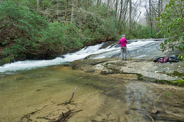
The trail from here up to the waterfall is a mile and a quarter along an old road that is steep, rocky, and badly eroded in a lot of places.  This is the steepest long section of trail that I've been on lately and I was feeling it.  I stopped quite often just to catch my breath and give my legs a break.  Luckily, the trail (road) follows Beech Creek up the mountain and there were a lot of smaller cascades I could admire during my breaks.  I caught another break at 1/2 mile from the creek crossing when I came across a nice wet weather waterfall coming in from the left.

bonus waterfall

I took an extra long break here, shooting still shots and video.  I really need to get back to this area when the weather warms and I can spend more time.  Areas like this look so much better when the plants aren't dormant and everything is greener.  I continued the trudge up the trail to the next spot where I had a legitimate reason to put my pack down.  About 1/2 mile from the little waterfall is a man-made stone wall.  In Kevin Adams' description of this hike he says that "the wall is the remains of an old rail support.  The rail was used to sluice rock from a corundum mine farther up the mountain to the crushers below."  Interesting!
 

 From here the road switchbacks to the left, but I wasn't paying attention and continued straight on what looked like the road.  It ended in a short distance at Beech Creek and this nice little 10' cascade.

small waterfall on Beech Creek

I knew something was wrong when there was no trail from here, so I pulled out the directions and saw I had missed the turn.  I still had another 1/4 mile of even steeper hiking left before the side trail to High Falls and this required even more stops to catch my breath.  There used to be a sign nailed to a tree indicating the side path to the waterfall, but now there's no tree and the sign is in a pile of rocks on the ground.


High Falls isn't visible from here, but it's only a short distance down to the creek and up into the cove and the waterfall.  It's really a magnificent sight and one of the finest waterfalls in the area.


A couple of big logs have fallen at the base of the falls, but the upper section is still clean and beautiful.  On the last trip I had climbed up the rocks to that section, but I didn't want to risk it today.  The rocks were wet and slippery and I didn't want to chance any kind of injury.  I was pleased with the shots and video I got, so after eating some lunch, I continued on.

Back at the Beech Creek Trail, the old road got even steeper and more eroded.  Finally after another 1/2 mile of this, the road leveled out a bit and became more of a trail instead of a washed out old road.  The trail still followed Beech Creek, but the water volume began to fade and the creek finally ended as a big wet area.  This section of trail passes through a nice section of the forest with a lot of beech trees - go figure.  In his description of the rest of the loop hike, Kevin mentions a Scaly Nature Trail.  There's no sign anymore, but I took the trail a short distance up to see if there was a view.  There was, but it's through the trees and I didn't feel like exploring any farther. 
 
view from the trail
From here the main trail does a hard 180 as it swings around Big Scaly Mountain.  The last 4 miles of the loop is just about all down hill.  The trail is steep, rocky, and eroded in places, but it wasn't as bad as I thought it would be.  I reached the junction of the Deep Gap Trail about 2:15 and made it back to my car right at 3 - well ahead of schedule.  Don't think I'll be doing that full loop any time soon, but hope to make it back to those waterfalls some time later this year. 


January 6, 2016 - Deep Gap Branch Trail, Southern Nantahala Wilderness area

Today's hike was mainly about one thing - getting back together with my hiking pal Bernie Boyer - waterfall finder extraordinaire!  If you have followed my web site in the past, you've seen me mention Bernie countless times.  He's been retired for years and spent a lot of his spare time studying topo maps and finding previously undocumented waterfalls.  He and his wife used to live nearby, but moved to north Georgia over a year ago.  My last hike with him was late November 2014 when a group of us hiked to Schoolhouse Falls before he moved.

the gang at Schoolhouse Falls

The plan today was for Cindy and me to meet Bernie and Brenda Wiley in Clayton GA, then drive from there over to the Southern Nantahala Wilderness area.  This area is actually in North Carolina, but the only way to get to it is through GA.  There are 2 NC waterfalls in this area that I visited years ago (and I would revisit tomorrow) and have directions on my site to the area here.  A North Carolina waterfall guide book by Melissa Watson lists another waterfall in the same area on Deep Gap Branch, so our mission today was to find that 40' waterfall!


Tate City Mall
Tallulah River Rd passes through the little community of Tate City, before ending at the parking area for the trail we were hiking.  The above picture might give you an idea of the size of the community along this stretch of gravel road.
 
entering the Southern Nantahala Wilderness area
There's only one trail leading off from this parking area and it gives access to both the Deep Gap Branch and Beech Creek Trails.  Our trail today would be the Deep Gap Branch Trail.  The guide book lists the waterfall we were looking for at about 1.3 miles up the trail with the last 0.1 miles as a bushwhack.  The trail wasn't in very good shape on this day.  A lot of that was probably due to all of the recent heavy rains in the area.  Sections of the trail probably looked like gushing creeks a few days ago and there were several downed trees we had to climb over.  At 0.4 miles in, the trail splits with our route heading up the left fork.  We had several creek crossings and wet areas to maneuver over and passed by this little wet weather waterfall.  It probably wouldn't have been worth stopping for if it weren't for the ice around it.


Along the way we also scoped out access to a couple of other creeks that have bigger waterfalls on them.  All of these are bushwhacks and we plan to hit them on another day.  We finally reached the point where we had to head off trail up to the waterfall, got to the point to where the waterfall was supposed to be and found this puny, pitiful looking waterfall probably less than 15' high.


waterfall on Deep Gap Branch Trail

This couldn't be it, could it?  Bernie matched up her coordinates with what he had on his GPS and Brenda went up creek a ways just to be sure.  This had to be it.  Even with the very small cascades below this section of the falls, one would have to be delusional to think this was 40' high.  Oh well - you don't know if you don't go.  We went and now we know.  There were some nice ice doodads hanging off of the clutter around the falls, and all 4 of us took time to shoot what we could before heading back.


ice doodads

On the way back we stopped at a small cascade along the Tallulah River that was actually nicer than the last one, then headed back to the vehicles.  As I said, there are some off trail waterfalls in this area and Denton Falls is off this same road back on the Georgia side, so we talked about meeting again soon for some more exploring.  You can view Bernie's pictures from our hike here.

small cascade on Tallulah River

Monday, January 4, 2016

January 1, 2016 - Jones Gap State Park, SC

Happy New Year everyone!  Cindy and I wanted to kick of the new year right by getting outside for a hike.  We picked the Jones Gap Trail in Jones Gap SP since we'd be hiking along a beautiful mountain river and would also be seeing a waterfall or 2.  Jones Gap SP is only about 40 minutes from our home in Hendersonville, so there was no need to get a real early start.  We got on the trail a little before 10am.  The Jones Gap Trail is 5.3 miles in length, but we were only going to do part of it, then turn around.

Middle Saluda River

The Jones Gap Trail is easy to moderate in difficulty.  There's only a gradual elevation change, but parts of the trail are very rocky and can be hard on ankles and knees.  Adding to the difficulty today was the fact that the trail was like a shallow creek in areas due to all the recent rain.  Our first destination along the trail today was Jones Gap Falls which is a little over a mile into the hike.  I have more info about the trail and how to get to Jones Gap SP on my web site here.  Just before the trail reaches the waterfall, it crosses the river on a nice foot bridge.  (Before this, the red blazed trail to Rainbow Falls splits to the right, but that will be another hike.)


Middle Saluda River at the footbridge

After crossing the bridge, the trail continues a short distance to a creek crossing and a side trail on the right that leads up to the waterfall.  Jones Gap Falls is about 50' high and had a lot of water coming over it today.  The spray from the falls at the viewing area was bad, so we didn't spend a lot of time shooting there today.  That was disappointing since the base of the falls has some interesting rocks and I was hoping to get some good video.  I did spot an Earthstar Puffball in the area which was a nice find.  It's only the 2nd one I have ever seen and Cindy had never seen one. 

Jones Gap Falls
Earthstar Puffball

We continued up the Jones Gap Trail after leaving the waterfall.  My friend Harry and I had hiked this years ago and I remembered another waterfall on a side creek about a mile or 2 past Jones Gap Falls.  The trail still follows the Middle Saluda River and there are a lot of smaller cascades on it along the way.  The high river level prevented us from going down to shoot until we got to this one spot where we did a little shooting and ate lunch.  I didn't know it at the time, but this slide is called Ben's Sluice.

Ben's Sluice


Back on the trail again, we continued on towards the waterfall that I remembered very little about.  Actually, I didn't even remember how Harry and I got here in the first place.  It turns out we came down the Coldspring Branch Trail from US 276 near Caesars Head.  This trail comes down and meets the Jones Gap Trail at a point about 2.75 miles from Jones Gap SP.  Cindy and I passed that trail on the left and the waterfall was just beyond that coming in from the right.

Cindy and me at Toll Road Falls

I did a little research when we got back home and found out that this little waterfall is called Toll Road Falls.  You can read the story behind that name here.  We could also see another waterfall through the trees up creek from the trail.  Getting to this one requires a bushwhack - and not an easy one.  There are a lot of downed trees and limbs all over the creek, woods, and at the waterfall so getting to a vantage point for a shot was tricky.  This waterfall is about 20-25' high and would be a nice one if it weren't for all of the clutter.  As far as I can tell, it doesn't have a name - upper Toll Road Falls maybe?

upper Toll Road Falls

We decided to call it quits after this.  The trail ends on US276, so we'll come back another day and do the rest of it from that end.  I know there's at least one named cascade in that stretch I haven't seen yet.