Happy New Year everyone! Cindy and I wanted to kick of the new year right by getting outside for a hike. We picked the Jones Gap Trail in Jones Gap SP since we'd be hiking along a beautiful mountain river and would also be seeing a waterfall or 2. Jones Gap SP is only about 40 minutes from our home in Hendersonville, so there was no need to get a real early start. We got on the trail a little before 10am. The Jones Gap Trail is 5.3 miles in length, but we were only going to do part of it, then turn around.
 |
| Middle Saluda River |
The Jones Gap Trail is easy to moderate in difficulty. There's only a gradual elevation change, but parts of the trail are very rocky and can be hard on ankles and knees. Adding to the difficulty today was the fact that the trail was like a shallow creek in areas due to all the recent rain. Our first destination along the trail today was Jones Gap Falls which is a little over a mile into the hike.
I have more info about the trail and how to get to Jones Gap SP on my web site here. Just before the trail reaches the waterfall, it crosses the river on a nice foot bridge. (Before this, the red blazed trail to Rainbow Falls splits to the right, but that will be another hike.)
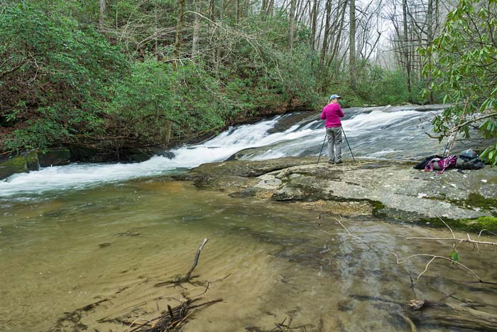
 |
| Middle Saluda River at the footbridge |
After crossing the bridge, the trail continues a short distance to a creek crossing and a side trail on the right that leads up to the waterfall. Jones Gap Falls is about 50' high and had a lot of water coming over it today. The spray from the falls at the viewing area was bad, so we didn't spend a lot of time shooting there today. That was disappointing since the base of the falls has some interesting rocks and I was hoping to get some good video. I did spot an Earthstar Puffball in the area which was a nice find. It's only the 2nd one I have ever seen and Cindy had never seen one.
 |
| Jones Gap Falls |
 |
| Earthstar Puffball |
We continued up the Jones Gap Trail after leaving the waterfall. My friend Harry and I had hiked this years ago and I remembered another waterfall on a side creek about a mile or 2 past Jones Gap Falls. The trail still follows the Middle Saluda River and there are a lot of smaller cascades on it along the way. The high river level prevented us from going down to shoot until we got to this one spot where we did a little shooting and ate lunch. I didn't know it at the time, but this slide is called Ben's Sluice.
 |
| Ben's Sluice |
Back on the trail again, we continued on towards the waterfall that I remembered very little about. Actually, I didn't even remember how Harry and I got here in the first place. It turns out we came down the Coldspring Branch Trail from US 276 near Caesars Head. This trail comes down and meets the Jones Gap Trail at a point about 2.75 miles from Jones Gap SP. Cindy and I passed that trail on the left and the waterfall was just beyond that coming in from the right.
 |
| Cindy and me at Toll Road Falls |
I did a little research when we got back home and found out that this little waterfall is called Toll Road Falls.
You can read the story behind that name here. We could also see another waterfall through the trees up creek from the trail. Getting to this one requires a bushwhack - and not an easy one. There are a lot of downed trees and limbs all over the creek, woods, and at the waterfall so getting to a vantage point for a shot was tricky. This waterfall is about 20-25' high and would be a nice one if it weren't for all of the clutter. As far as I can tell, it doesn't have a name - upper Toll Road Falls maybe?
 |
| upper Toll Road Falls |
|
We decided to call it quits after this. The trail ends on US276, so we'll come back another day and do the rest of it from that end. I know there's at least one named cascade in that stretch I haven't seen yet.


No comments:
Post a Comment