Sunday, August 28, 2016

August 11, 2016 - Twin Boulder Falls, Pisgah National Foresst

Since the creek levels were higher than normal, I decided to revisit a waterfall I hadn't been to since 2005. In 2003, Cathy, KT, Harry and I decided to explore an off trail section of Right Fork in the Pisgah. The Daniel Ridge Loop Trail passes by part of this creek, but we wanted to see what was up creek from where the Daniel Loop Trail leaves the creek. Since there's no trail, we decided to just wade and rock hop our way up as far as we could. Long story short, we found a lot of nice cascades, then an excellent 50-60' free falling waterfall. We passed through 2 huge boulders just before the waterfalls, so I named the falls Twin Boulder Falls. That's not an official name, but it didn't have a name and I thought it deserved one. There was no other info about it that I could find at the time. I never added this to my web site since it was off trail and I was hesitant about sending tourists into the danger zone.

When Kevin Adams was working on the 2005 edition of his North Carolina Waterfalls book, he contacted me and we exchanged info on waterfalls one of us had and the other one didn't. He didn't have Twin Boulder Falls, but was only using official names for his book, so he called it the waterfall on Right Fork. Fast forward to 2016 and the 3rd edition of Kevin's NC Waterfalls book. This time he decided to use unofficial names, so if you have either book you can look it up for specific directions.

In the current book, the description says that enough people have been visiting this waterfall that a crude path can be followed from the main trail all the way up. I decided to give this a try and skip walking the creek to save time. The hardest part of this was when I first left the trail in the 3rd switchback. I got down in the gully mentioned in the description, but missed picking up the new trail until I had already climbed over some fallen trees and gone down a steep bank. Once I found the trail, it was fairly easy to follow, but blocked by more fallen trees that I had to climb over before crossing the creek.

Once I made it across the creek, the trail was easy to follow for the most part - just like Kevin says in his book. I didn't realize it until I got back and looked at the GPS that I had gained 1280' in the 2.8 miles it took to get to the waterfall. I didn't bother to stop along the way to shoot the smaller cascades, but began shooting at the 2 boulders. The waterfall was looking good today and turned out to be a good choice for the day's activity. First the video, then the pictures.


the twin boulders


Twin Boulder Falls

On the way back I stopped at a smaller no name waterfall that's visible from part of the Daniel Ridge Loop Trail. It's maybe 10' high and pretty nice in the right conditions.


August 9, 2016 - Cedar Rock and Grogan Creek Falls, Pisgah National Forest

Today seemed like a good day to visit more waterfalls, so Cindy and I headed back to the Pisgah NF. Cedar Rock Falls and Grogan Creek Falls were both on my list for better video, so that's where we headed. Directions to both of those waterfalls can be found on my web site here.

Our first stop was Cedar Rock Falls and I was disappointed to see that there was more water in the creek than I had hoped for. Don't get me wrong, I still enjoy being at the waterfalls when shooting conditions aren't ideal. With Cedar Rock Falls, I just couldn't get to a couple of the places where I wanted to shoot from, so I didn't get all the video and stills I had wanted. Here are a couple of shots I did get. I'll make a return trip to get video some other time.


Cedar Rock Falls

A couple of dead trees have fallen into the picture since the last time I was here. There are also several old dead hemlocks still standing around the waterfall, and when those fall, the place will be a mess.

There's also an upper Cedar Rock Falls, but we decided to save that for our last stop of the day. Our next destination was Grogan Creek Falls which is about a mile up the trail. This waterfall is small also, but has a lot of character with the small ledges that make up part of the waterfall. Grogan Creek was flowing high also, but the waterfall was looking pretty good.


Grogan Creek Falls

I've been here before when the creek was very low and I like the full look much better. It's hard to believe just how loud this waterfall was today. I did shoot video here, but there wasn't enough footage to put together a decent length video, so I'll go back at some other time in lower flow, shoot some more, then combine the clips from both days. This is a really nice spot and I highly recommend going here. The 2 mile hike is fairly flat for the most part and not many people visit this waterfall.

After soaking in the scenery here, we headed back the way we came and did stop at upper Cedar Rock Falls. It's right at a nice primitive camping spot, but requires a short scramble down a steep bank to get a view. This waterfall isn't as high or nice as the other 2, but is worth a stop if you are at this point on the trail.

Upper Cedar Rock Falls


Monday, August 22, 2016

August 5, 2016 - Slick Rock Falls - Pisgah National Forest

I've been revisiting some of the better known waterfalls for updated photos and trail conditions, and also to try to get better video that I can use on my web site. I'd like to have a video of each waterfall I have on the site, but going back to all of them will be a major task. Today I picked Slick Rock Falls to begin with. I thought I'd be in and out in no time, then move on to another waterfall. I should have known better.

Directions to Slick Rock Falls can be found on this page of my web site. The waterfall can be seen from the forest road, but a very short hike up to the waterfall is necessary to get photos. I had the waterfall to myself which is always nice. Before anyone else showed up, I headed behind the falls to the cave area so I could get those shots without people. I spent quite a bit of time back there setting up shots and waiting for the sun to be covered by clouds.


From there I moved to the front of the waterfall, snapped a few quick ones and shot some video while the sun was hidden. It was directly above the waterfall at this time of day. I had just put all of my gear away when the sun broke out of the clouds and illuminated the light mist that was coming from the spray of the waterfall. I couldn't see this with the sun behind the clouds. I quickly got the gear back out and began shooting again. The still images weren't turning out like I wanted, so I switched to video. The sun kept going in and out of the clouds, so I ended up staying here another hour. Here are the photos from that position, but be sure to check the video below also.


I headed back up to the side view of the waterfall you first get when approaching the falls from the trail. A few people began to show up, so I chatted with them while patiently waiting for the kids to get out of the picture. I spent about 45 minutes more in this area and figured I had milked everything I could from the waterfall on this day. Instead of going anywhere else, I just called it a day and headed back to the house.


Saturday, August 20, 2016

August 3, 2016 - Courthouse, Cody, and Chestnut Falls - Pisgah National Forest

I've been wanting to get back up to the Courthouse Creek area all summer, but was holding out until water levels were higher. This summer's drought has really had an effect on the creeks. I was surprised by the higher levels I saw in Lake Toxaway the other day, so I thought today would be a good day for Courthouse. Plus, someone had posted on FB that a huge dead hemlock had fallen at Courthouse Falls and I was eager to see just how much of the view of the waterfall was blocked.

I only saw 1 vehicle along FR140 as I made my way up to the Courthouse Falls trail head - my first stop of the day. Directions to Courthouse Falls and Cody Falls are on this page of my web site. There was no one here either and skies were still overcast - excellent shooting conditions. I noticed that the forest service had added orange trail blazed to the blue ones that were already there. The orange was now for the Courthouse Falls Trail and the blue was still the Summey Cove Trail. Before arriving at the base of Courthouse Falls, there's a view of the waterfall though the trees that I like to shoot.

Courthouse Falls from the trail

That view was still good, but I could see the big downed hemlock through the trees and shrub. A set of wooden steps leads from the end of the trail down to the base of the falls. When that hemlock fell, it damaged part of the steps, but not enough to make them unusable.

the damage done

I didn't get a good close up shot of the damage, but maybe you can tell from that shot that most of the damage was done to the lower section. My favorite spot to shoot Courthouse Falls from was a big rock in the middle of the creek. This is what it now looks like from that rock.

view from the rock

The hemlock also brought down a couple of younger live trees, so their branches and leaves are among the litter. My guess is that all of that mess will be there for a while. It'll take a huge flood to wash all that out of the picture. But - there is good news if you have a wide lens and don't mind standing in the creek. I took these next 2 shots with a 10-18mm lens on my Sony a6000 and was standing in the creek just in front of all the debris.


Courthouse Falls

I spent quite a bit of time here and thought I got all the shots and video I wanted. My next stop was Cody Falls which is just down creek from Courthouse Falls. The waterfall is a short distance up Mill Station Creek from it's confluence with Courthouse Creek. I hadn't been to this 25' high waterfall since 2005 which is a real shame. Courthouse Falls can get crowded, but very few people go to Cody Falls. One reason could be that there's no trail to it. The sure fire way to find it is to wade and rock hop Courthouse Creek down to Mill Station Creek, then head up to the waterfall. There's also a way to cut down the steep bank from the Courthouse Falls trail, but you have to come out at exactly the right place or you'll be on the rock cliff surrounding the falls. My plan today was to take the creek down, then find the best place to head back up so I could describe that way in my directions to the waterfall.

Following Courthouse Creek down wasn't an easy task task today since there was a lot of tree debris in the creek. I made it to Cody Falls and was very pleased to see that no logs had washed into the waterfall. The sun was now in and out of the picture, so I spent quite a bit of time waiting for cloud cover, but it was well worth it. The waterfall is in a small little cove and the wide angle lens came in handy here also. The water flow wasn't as high as I expected, but that didn't turn out to be a bad thing.


The sun was out enough at times to really bring out the red color of the rock without washing out the entire scene. The green moss just added to the beauty. This is such an awesome little spot! Getting back up the bank wasn't as bad as I thought it might be. I ended up at exactly the right spot back up on the Courthouse Falls Trail and have that updated description of how to get down in case you don't care to creek walk.

The last stop of the day was Chestnut Falls which is accessed from a different spot along FR140. Those directions are here. It had been a few years since I'd been here also, but more recently than 2005! The trail is still in good shape, but this waterfall could have used some more water. I took a few shots, then the skies really darkened, so I put all the camera equipment away and prepared for the rain. After 15 minutes, there was no rain and the skies lighted, so I got everything back out and continued shooting. Soon after that, the skies cleared completely, but by then I was about done for the day. Below are a couple of photos of Chestnut Falls, then a video including all 3 waterfalls.


Friday, August 19, 2016

August 1, 2016 - DEW Falls and White Owl Falls

Today I decided to revisit 3 waterfalls I hadn't been to in a while - DEW, Johns Jump, and White Owl Falls. All 3 are very close and don't require much hiking. You can find directions to all 3 falls on this page of my site. All 3 waterfalls are small, but nice to visit and make good photo subjects with the right conditions.

I began the day at DEW Falls and had the waterfall to myself. It wasn't supposed to rain until later in the day, but late morning the skies were already fairly dark. I had just started shooting when the first rain drops began to fall, so I quickly got the camera back in the bag and pack and covered the pack. I had just got my poncho on when it started raining harder - and harder. Since it was warm out, I really didn't mind. Actually, the photos turn out better when all the rocks and foliage are wet and you use a polarizing filter to cut the glare. After almost an hour of steady rain, it let up enough for me to get the camera back out.


DEW Falls
 
I could have stayed longer, but I got a late start and didn't want to be out all day. The skies were also showing signs of clearing - not good for photography - so I opted to skip Johns Jump Falls and head to White Owl Falls. White Owl is one of my favorite small waterfalls. I really like the way the water flows over the rock. Back in 2010, a live tree fell over right in front of the waterfall ruining the chance of any good shots. People slowly sawed away at the limbs until now all that's left is the trunk on the left side of the falls. I got lucky here. The skies stayed overcast just long enough for me to get a few shots and video. Once it cleared, I was done shooting for the day and headed back to the house.


White Owl Falls


Wednesday, August 10, 2016

July 18 & 28, 2016 - Bennett Cove Falls, No Name Falls, and Poundingmill Branch Falls - Pisgah National Forest

Back in 2007, my friend Bernie Boyer spent a lot of time exploring the creeks coming off the south and east sides of the Pisgah Ridge. Some of the creeks already had named waterfalls that were nice, but there was no documentation on what was on the other creeks. It turns out that there was a lot to be seen. Bernie was retired at the time - and I wasn't - so he would go out looking during the week, then take me to what he found on the week ends. I added the pictures to my PBase galleries, but didn't add the waterfalls to my main site since they were all off trail. Now that Kevin has added these waterfalls to his new book, I'm going to revisit them so I can add them to the site. If you have Kevin's book, these waterfalls are listed on page 185.

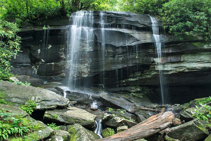
On the 18th, I set out Bennett Cove and Cherry Cove Falls. Unfortunately, this area has been in severe drought lately and the small volume creek in Bennett Cove was really low. Bennett Cove Falls was still very pretty and serene, but nothing like when I was there in 2007. Directions to the creek and waterfall are on my site here. Most of the hike to this waterfall is along a gated grassy forest road, then a lesser foot path to the creek, but getting to the waterfall requires off trail traveling.  This isn't for everyone, but if you want to really increase the number of waterfalls you visit, you have to do it. There are some really beautiful waterfalls to be seen.

There are a couple of smaller sliding waterfalls on the way up the creek to the main one, but nothing worth showing with puny water flow. Bennett Cove Falls is about 25' high in 2 sections and sits in a beautiful little cove. I shot some video, but there really isn't enough for a full video, so I'm saving it until I can get back to some of the other waterfalls in the area and combine the footage into one video. For now, here are a couple of shots. If you click the link above, you can see photos from 2007 when the creek had more water in it.

Bennett Cove Falls

After leaving this waterfall, I headed over to the unnamed creek in Cherry Cove. This is one that I didn't get to when Bernie did his recon in 2007. Unfortunately, fallen trees now cover the waterfalls and I didn't even take any pictures.

July 28 - I decided to head back to this area today since there's been more rain. I messaged my friend Brenda Wiley to see if she wanted to join me and she happily accepted my invitation. Brenda has a great web site where she chronicles her adventures. I had asked if she had anyone else she wanted to invite and she mentioned a hiking companion of hers - Mark. He was also excited about going and we all met at the Pisgah visitor center and left from there. I had planned to hit Poundingmill Branch Falls first, so that's where we headed. Unfortunately, the rain we got wasn't enough to help the creeks out, but the waterfall was still nice anyway.

Poundingmill Branch Falls

Both Brenda and Mark were excited to have seen it. It's hard to tell from this photo, but it's about 40' high. Directions to this waterfall are here and you can also see a picture of the waterfall from years ago. From here we headed over to what Kevin is calling No Name Falls in his book. The creek that the 2 waterfalls are on doesn't have a name and either does the cove that's they are in. Directions to the creek and waterfalls are here, but I don't have any pictures from this day to show you because I didn't take any. There was barely a trickle coming over the waterfall. There are pictures from my 2 previous visits at that link, however. When we where walking through one of the fields to get to the creek, there were sunflowers in bloom. I had never seen one in the wild, so I had to snap a picture.

Common Sunflower

Neither Brenda or Mark had been to Bennett Cove Falls, so I took them back up there while we were in the area. The waterfall looked the same, so I skipped pictures and just enjoyed the scenery and the company. It was a real steamy day, so we all got soaked in the falls before heading back to the vehicle.


Monday, August 8, 2016

July 15, 2016 - Little Bradley Falls


Cindy's grandson Salomon has been with us for a week during his summer vacation and today was his last day here. We had him out hiking and waterfalling every day except one. He really liked going to waterfalls, so I thought he would enjoy Little Bradley Falls where he could play in the water and climb on the rocks. Plus, I hadn't been in a while and I've been wanting to get back for updated photos and video. Directions to the waterfall can be found on my site here - http://www.ncwaterfalls.com/little_bradley1.htm

We got to the parking area around 9:30. Some folks asked if we knew where the waterfall was, so I invited them to hike along with up. They were from the Raleigh area and were up for a long week end. When we got to the falls, a group of women were just finishing up rappelling down the waterfall so I didn't get a chance to get any photos. At least they were now out of the way, though.

Salomon got in the water almost immediately. The folks that joined us on the hike didn't stay long and we ended up with the waterfall to ourselves for about an hour. After close to 3 hours there - and quite a few more people showing up - we headed back to the vehicle. A good time was had by all. Below is some video I shot, then a few photos.