Saturday, July 9, 2016

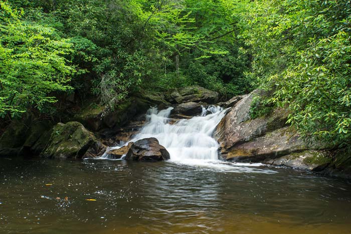
June 28, 2016 - Big Bearwallow Falls, Pisgah National Foresst

Bernie, Harry, and me at Big Bearwallow Falls in 2007


Bernie found this excellent waterfall back in 2007 and took Harry and me there shortly afterward. It's really close to NC215, but not visible from the road and down a very steep bank. I kept it off of my web site for the longest time because there's no trail to it, but decided to add it and had to go back to get specific directions. I have those posted here.

Kevin also added this waterfall to his new book, so I used the mileage he had for the pull off on 215. Odometers can vary from vehicle to vehicle, so my 2.6 miles put me at the pull off he talks about walking 75 yards up the road to begin the hike from. I could tell that this was the one because of the trash that had been thrown over the guard rail. Since there's no trail, I just hopped the guard rail and descended to the creek. I remembered Bernie taking us up the bank to an old road on the opposite side of the creek, so that's the way I went. I just couldn't remember how far down the waterfall was. I finally found it and ended up spending over an hour there shooting stills and video and enjoying the waterfall. I could hear traffic up on 215 and I'm sure very few if any of the people know that there's a waterfall here.

Big Bearwallow Falls


Friday, July 8, 2016

June 27, 2016 - waterfalls on Sam Branch and in Wash Hollow

It's been years since I have been to the upper reaches of Sam Branch and I thought today would be a good day to do it again. Water levels in the area are down due to a lack of rain which would make the trek a little easier since a good portion of this is a bushwhack up the creek. There's a lower waterfall on Sam Branch that I have directions to on my site here and this is the same point from which I began the hike today. Wash Hollow Falls is also accessed from this same parking spot.

It rained a bit before I got to Sam Branch which made the going very slippery. I don't give directions on my site to the upper waterfalls on Sam Branch, but as soon as you cross the creek heading towards Wash Hollow, there's a really steep rock face to climb, then a steep section of muddy and slippery trail to get up. Not many people go up here, so it's not really much of a trail.

This trail ends not too far up, so it was soon time to hit the creek and start climbing boulders. This is the 1st area I got to that was photo worthy.


The cascades in the first photo are small, but the upper drop in the second photo is about 10' high. Not too far above this is another waterfall - maybe a 15 to 20 footer.


I finished shooting it and was getting ready to find a way up past this when it started raining like crazy. It let up a bit after about 10 minutes, but I had to decide whether or not I wanted to continue. The forecast called for on and off storms all day and I had no way of telling what was in the area. I opted to play it safe and head back down. This was really disappointing as the wet rocks make for excellent photos. The wet really brings out the colors in the rocks, especially if you add a polarizing filter to the lens. Wet rocks are also really slippery and I'd like to enjoy my retirement a bit longer before I die.

Of course, once I got back down, the sun was peeking in and out of the clouds. Since I was already here, I went over and checked out Wash Hollow Falls. The flow of the falls was way down, but the rock wall was wet and colorful.


I spent about an hour here shooting before the next storm hit - and it was a gusher. I was scurrying around putting gear away to keep it dry and got soaked in the process. After about 15 minutes huddled under my poncho, the rain let up again and it was time to head back to the car. I got to Sam Branch Falls and just had to stop for one last photo. I'll try again for the upper stuff on a drier day.


I shot some video along Sam Branch, but I'm going to wait to put together a video until I have footage of more of the creek. For now, here's what I shot at Wash Hollow Falls.


Saturday, July 2, 2016

June 16, 2016 - Back to Roan Mountain

We considered getting up early today and heading up to Roan for a sunrise, but I'm glad we didn't. We got up to Carvers Gap around 8AM and low clouds were really obstructing the views. As we headed towards Round Bald, we passed several photographers heading towards their vehicles that were done for the day. I was thinking that it was a little too early to be giving up!

By the time we headed off Round Bald, the clouds began to lift just a bit, then a little bit more.


Our destination today was Grassy Ridge which is about a 3 mile hike one way. In a good year, the rhododendron display can be superb - much better than if you just stop at Jane Bald. We were beginning to see some blue skies as we took the Grassy Ridge trail off of the AT. On the way up is a  rhododendron tunnel and we had to stop for a shot. Then I had to stop for another shot looking back over the tunnel.


The blooms really pick up the farther out you go on Grassy Ridge and it looked like we hit it right at peak bloom. The skies really began to clear once we got to the good stuff on the ridge.


The trail ends (behind us) a little bit farther than we are in the next 2 shots, but I've been there before and the views from here are better. We were surprised at the few people that we saw in the 2-3 hours that we were here. That will probably change this coming week end since it's Rhododendron Festival week end. I'm so glad we don't have to put up with the week end mobs any more!


June 15, 2016 - Waterfalls in the Dennis Cove area of the Cherokee National Forest

Day 2 of our camping trip was dedicated to visiting a few waterfalls in the Dennis Cove area of the Cherokee National Forest close to where we were camped. The first falls of the day was Coon Den Falls. More info and directions to the falls can be found on my web site here. The directions to the trail head we found before the trip seemed pretty straightforward, but turned out to be a little confusing. We passed right by the trail head on Dennis Cove Rd without noticing it even though there is a small carsonite sign marking the trail. There is no parking right at the trail head, so we parked in an area farther down the road and walked back until we found the trail. The trail is a steady uphill climb all the way to the waterfall, but not really very difficult. Water levels in this area are lower than normal, so the waterfall wasn't looking it's best, but it was still worth the hike.


Coon Den Falls

The next waterfalls on our list were along the Laurel Fork Trail which began right across from where we parked for Coon Den Falls. Dennis Cove Falls is on Laurel Fork and is actually 2 separate waterfalls. The hike isn't that difficult, but it requires 3 wet crossings of Laurel Fork. There used to be log bridges with cables at these crossings, but the logs are now gone. The cables are still there, but are basically useless. We knew this ahead of time, so we wore boots that we didn't mind getting soaked. Directions and more particulars on the falls are on my web site here.

The creek crossings weren't that bad, but might have been really dangerous in high water. The first part of Dennis Cove Falls that we came to is considered the lower falls. It's a very small waterfall, but in a very pretty setting. The upper waterfall looked nice in the pictures we saw before we came, but a couple of dead trees have fallen in the middle of the waterfall making it a lot less photogenic. It's still a nice spot, though. Below are photos and video of both.  The bird in the video is a Louisiana Waterthrush we saw with what looked to be a salamander in it's mouth. We guessed that we were very close to it's nest at this point and it was trying to tell us to leave.

Lower Dennis Cove Falls
Dennis Cove Falls

The trail map showed a Firescald Falls about a mile and a half farther up the Laurel Fork Trail, and that was our next destination. The hike to it wasn't that bad, but we had several more wet creek crossings to deal with. The little info we found online about this waterfall before the trip showed an easier way to get to it via a gravel forest road and when I go back, that's the way I will go. When we got to a waterfall I recognized from the pictures online, the GPS and map showed we were on Little Laurel Fork. Firescald Branch comes into this up creek a ways, and apparently there are 2 waterfalls right where the creeks meet. Water flow was really puny on this creek and we were getting short on time, so this will be on a return trip to the area.

waterfall on Little Laurel Fork

June 14, 2016 - Roan Mountain

The middle of June is when Roan Mountain puts on a spectacular show of Catawba rhododendron and flame azaleas blooms. In years past, we've only made day trips up there to see the show, but this year we decided to camp for a few days. Roan Mountain State Park was the first place Cindy checked for availability and it was just about full. She expanded her search and found a nice campground on Watauga Lake in Tennessee that caters more to tent campers - Cardens Bluff. Turns out it's only a 45 minute drive from Roan, plus there were waterfalls close by that I hadn't been to.

We got an early start and had the campsite set up by early afternoon. Today we decided to head up to Roan and check on the bloom situation. It was a nice sunny day and we knew from years past that the weather can change in an instant on Roan and that this could be the only clear day we would have. When we got to Carvers Gap, there was nowhere to park which we thought was a bit unusual for a week day. The blooms were gorgeous here, so we tried our luck at the nearby Rhododendron Gardens. Peak bloom was still a few days away here, but it was still beautiful.


There were a few other wildflowers blooming also, but the one that caught our attention was the columbine. It sure doesn't look like the native columbine Aquilegia canadensis so I thought that they were maybe escapees from a nearby garden.

Roan columbine
There's a trail in this area that goes out to a view from Roan High Bluff, so we headed there next. There aren't any rhododendron here, but there's an excellent 180° view. Here's part of the view.

view from Roan High Bluff

It was now about 2:30, so we drove back to Carvers Gap and found a spot to park. Right out of the car, the rhododendron were gorgeous. We only went as far as Engine Gap today, but what we saw was spectacular. Several people coming back from Grassy Ridge told us that it was the best they have seen in years. That would be our destination on Thursday, but for now, here's a bit of what we saw today.

view up the hill from Carvers Gap
artist painting Jane Bald and above
flame azaleas
looking towards Jane Bald
flames, rhodos, and a view


Tuesday, June 21, 2016

June 10, 2016 - Courthouse Rd (FR140) finally reopens! Red Rock and Kiesee Falls

Courthouse Rd is a 3 mile long forest road that has trail heads for several waterfalls. The most popular is Courthouse Falls, but the 2 Kiesee Falls, Chestnut Falls, and the waterfalls on upper Courthouse Creek area accessed from that road also. It has been closed since August 2015 for a bridge repair and was supposed to reopen in early spring, but was delayed. Yesterday, the forest service posted on their web site that the road was to reopen at 10am on the 10th, so Emily, Todd and I made plans to meet at the gate around 9:30 and wait. Our plan was to hike Courthouse Creek up to Red Rock Falls, then come back down the road and do Kiesee and Upper Kiesee Falls.

The gate was opened before 10 and we were the first vehicle in. Red Rock Falls was the first destination, so we headed to the end of the road and parked there. I have more info about the waterfall on my site here. We were hoping for a cloudy day so the pictures would be better, but it didn't look like that was happening. It really didn't matter since it was a beautiful day to be out and it was good to be back in this beautiful area once again. On the way up Courthouse Creek, we stopped at a couple of smaller waterfalls that were still mostly in the shade.


The first one is about 10' high and the second maybe 6-8'. By the time we got to Red Rock Falls, the sun was mostly on the waterfall and getting good shots became difficult. Quite a bit of post processing helped out a bit.


Red Rock Falls
We hung around here for quite a while hoping a cloud would pass and even out the lighting, but none did and it was time to move on. Instead of heading to the other waterfall up creek, we opted to take our time going back before doing Kiesee Falls.

There are several small waterfalls and cascades along Courthouse Creek, but to see them up close you have to leave the trail and walk up the creek. It's a lot of fun and is a combination of walking in the creek, rock hopping, and bushwhacking. We've found quite a few waterfalls by doing this up creeks that have no trails beside them. A lot of Courthouse Creek flows over exposed bedrock that is brightly colored when wet as shown in the above pictures of Red Rock Falls, and there are also several pothole areas. Below are more photos that show off some of the creek's beauty.


a very happy Emily in one of the amazing potholes


We stopped at what's called Upper Courthouse Falls, but I didn't bother with pictures of it. The last shot above is a small waterfall right above Upper Courthouse and it seemed more photo-worthy.

We were back to the vehicle by around 2, then headed back down Courthouse Rd for about a mile to the parking area for Kiesee Falls. When I first attempted to find this waterfall back in 2001, the general thinking among waterfallers was there was only one waterfall here. We later learned that there is also an upper waterfall and my friend Bernie Boyer helped bring a trail to that waterfall out of the darkness. You can read all about how to get to the 2 waterfalls on my site here. The directions I had on the site before this were sketchy at best and I was hoping a revisit would clear things up. We began with Kiesee Falls and it was just as difficult to get to as it was before. There's decent trail part of the way, then we had to leave the trail and follow the creek up to get to the falls. It's in kind of a mini box canyon and going up the creek is the only access. The going wasn't bad at first, but became more difficult the closer we got to the falls. The reward in the end was worth the difficulty. Kiesee Falls isn't that big, but the huge pothole between the drops is a geological wonder and the entire setting is really beautiful.

Kiesee Falls
 

Todd in the picture for scale
Upper Kiesee Falls is just above this one. If Todd were about 10' taller, he'd be able to see it from where he is in the above picture. The problem is that you can't scale the walls of this waterfall to get up there. In the areas just back from the falls, the soil layer on the steep slopes is very fragile and people can undo dozens of years of Mother Nature's work trying to scramble up them. So we backtracked to a good spot to get back up to the main trail that continued on to Upper Kiesee. There is now a very obvious side trail that leads down to the base of the waterfall, but there's a tricky drop at the end that is slippery when wet. It wasn't bad at all today. The upper waterfall is a little more open and there's an even bigger swimming hole. We hung around here about an hour, then headed back to the vehicle then back to civilization.

Upper Kiesee Falls
 

Emily wading out for a shot